Across the country, water utilities, municipalities and community organizations are using Geographic Information Systems (GIS) to improve the delivery of safe drinking water. GIS technology addressing many challenges facing the water “eco-system”: managing water assets, collaborating across users and organizations, cataloguing potential sources of water contamination, to name a few.
In Marion County, Indiana one way GIS is used to improve the reliability of water data is through mapping of potential and known groundwater contaminant sources. Each year the Marion County Wellfield Education Corporation (MCWEC) uses real-time GIS apps to complete a drive survey cataloguing businesses in the wellfield protection areas (wellfields) which could be potential sources of groundwater contamination. This data is provided to the public (at a de-identified level) as well as to the water utilities serving the county. Having updated data that is searchable and provided as points located on a digital map is a game changer in quickly identifying where potential contamination might be coming from.
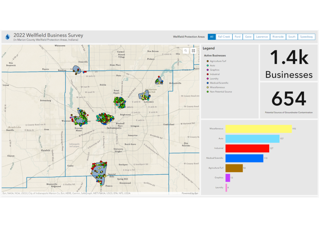
Additionally, the state of Indiana and the Indiana Department of Environmental Management are leaders in sharing digital data layers through Indiana Map. The Indiana Map provides a wealth of information regarding known contaminated sites. These layers can be incorporated with internally collected data to produce a single source of truth digital dashboard and dataset which includes both known and potential water contaminants.
Each year MCWEC publishes a public report where users can view collected and downloaded data in an ESRI StoryMap.
Data collection, managing data permissions, and creating real-time dashboards are just a few ways technology can be used to protect people from contaminated water. MCWEC is available to consult with municipalities and water utilities across the country on ways to use GIS to make informed decisions about water quality and pollution prevention. Groundwater is our drinking water – protect it!
Note: This post is one in a 3-part series on how GIS can be used to protect drinking water. Stay tuned for Part 2 (Planning for Lead Service Line Replacements) and Part 3 (Protecting Drinking Water in the Global Community).