 The US Geological Survey (USGS) continuously monitors the levels of groundwater around the country with more than 1,500 stations. Indiana has over 40 stations, two in Marion County.
The first station, known as Station Marion County 35, is located downtown, near the Indiana War Memorial and the Veteran’s Memorial Plaza at the intersection of Meridian Street and North Street. At this station, the USGS has been continuously collecting data for nearly ten years, beginning in July of 2008. Recent water levels measurements put depth to groundwater at approximately 41 feet below the ground surface (ft-bgs). Historically, groundwater levels have varied from a high of 30 ft-bgs in 1991 to a recent minimum of 41.3 ft-bgs earlier this year.
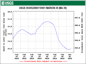
The second station, known as Station Marion County 39, is located northeast of downtown, near Newfields (previously the Indianapolis Museum of Art) near the banks of the White River. At this station, the USGS has been continuously collecting data since early 2012. Recent water level measurements, put the depth to groundwater at approximately 15 ft-bgs. Historically, groundwater levels have varied from a high of 7 ft-bgs to 21 ft-bgs, both record in August of 2013.
You may be wondering why groundwater levels are different in each of these wells, since they are both in Marion County. The answer is that the elevation of the ground is about 12 feet lower at Station 39, and groundwater at station 39 is also likely under the hydraulic control of the White River. This means that the level of water in the White River, which can be affected by rainfall and withdrawal and discharges of water upstream.
If you are interested in reviewing more data or in details of the program, check out the USGS’s Groundwater Data for USA webpage.
